


Precinct 16, Richland Parish, Louisiana
About
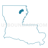
Outline

Summary
| Unique Area Identifier | 590381 |
| Name | Precinct 16 |
| County | Richland Parish |
| State | Louisiana |
| Area (square miles) | 0.51 |
| Land Area (square miles) | 0.51 |
| Water Area (square miles) | 0.00 |
| % of Land Area | 100.00 |
| % of Water Area | 0.00 |
| Latitude of the Internal Point | 32.46215210 |
| Longtitude of the Internal Point | -91.76458600 |
Maps


Graphs
Select a template below for downloading or customizing gragh for Precinct 16, Richland Parish, Louisiana


Neighbors
Neighoring Voting District (by Name) Neighboring Voting District on the Map
- Precinct 14, Richland Parish, LA
- Precinct 17, Richland Parish, LA
- Precinct 18, Richland Parish, LA
- Precinct 21, Richland Parish, LA